Application of Remote Sensing for the Mapping of Geomorphological Accidents of Mount Cameroon: Vectorization of the Probable Lava Flows Trajectories

International Journal of Earth Science and Geophysics
(ISSN: 2631-5033)
Volume 8, Issue 1
Research Article
DOI: 10.35840/2631-5033/7559

Article Formats
Application of Remote Sensing for the Mapping of Geomorphological Accidents of Mount Cameroon: Vectorization of the Probable Lava Flows Trajectories
Table of Content
Figures
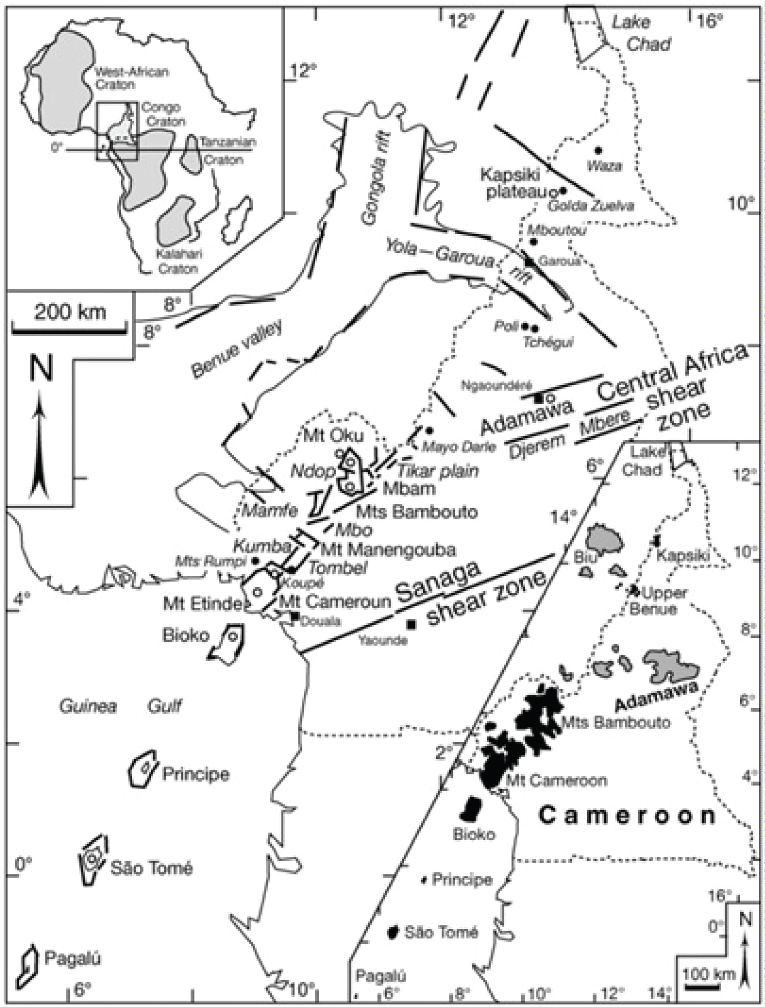
Figure 1: Cameroon hot line extending...
Cameroon hot line extending from Pagalu island to Lake Chad, between the West African and the Congo cratons (upper caption, after [23]). In the continental domain, it is a succession of horsts and grabens (in large italics) are indicated.
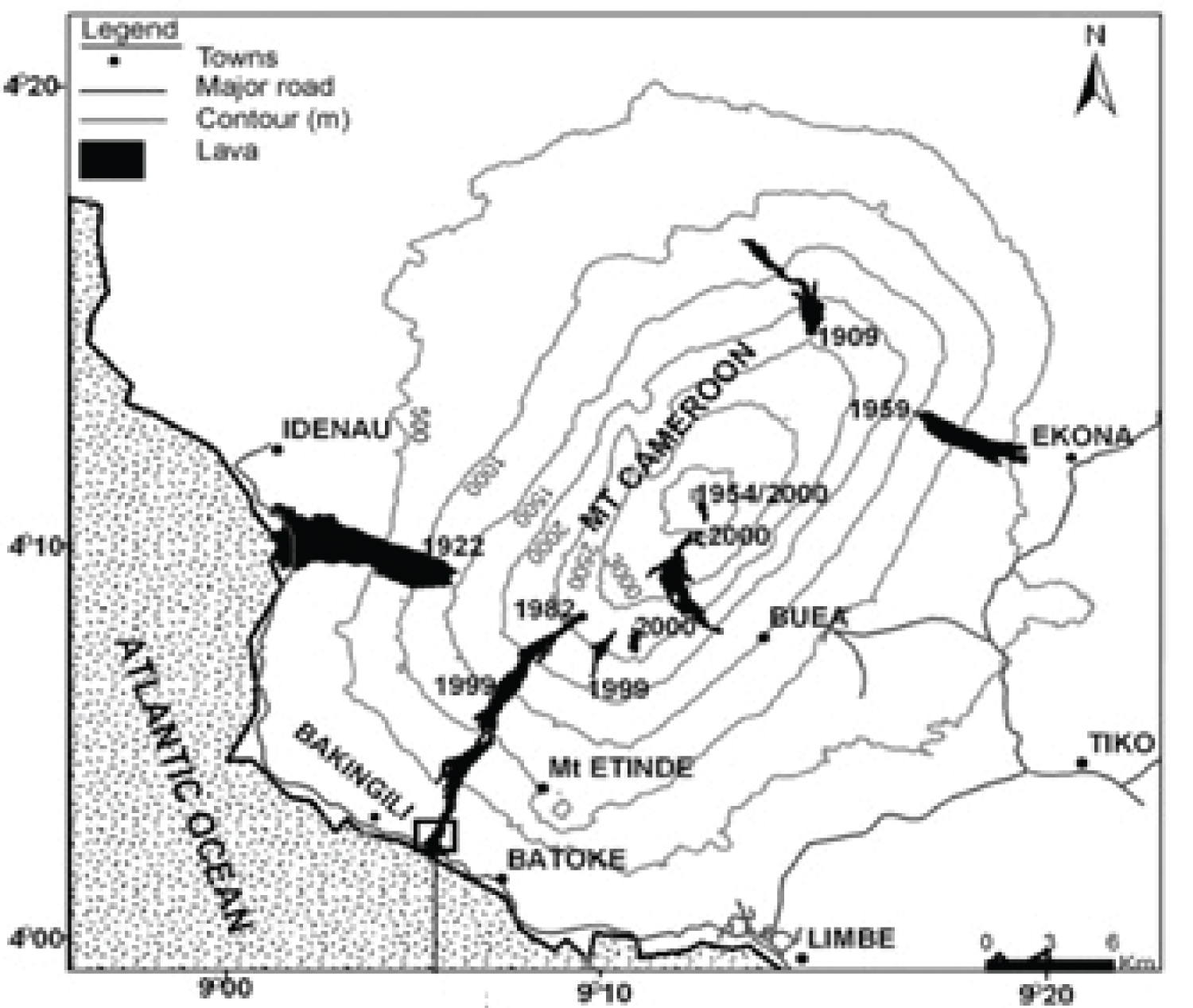
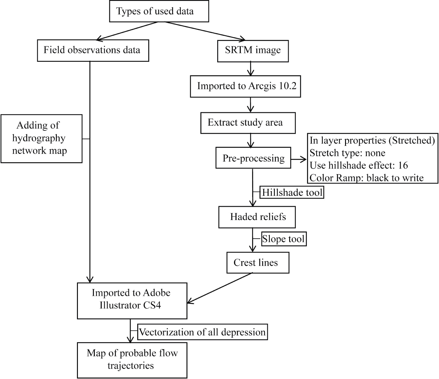
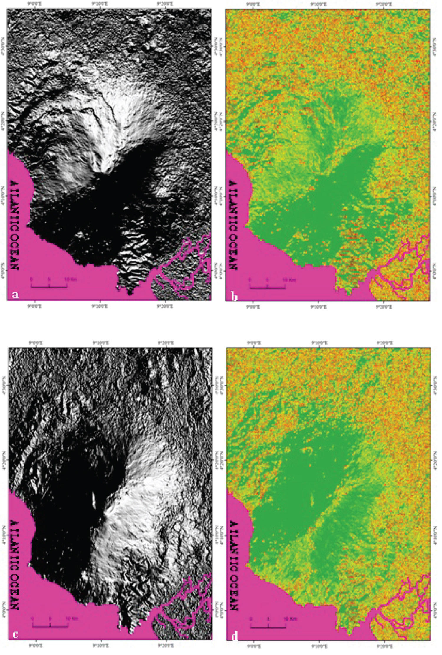
Figure 4: Maps of shaded relief and....
Maps of shaded relief and crest lines on the N and E flanks of Mount Cameroon. a) Shaded relief of the N flank; b) Crest lines of the N flank; c) Shaded relief of the E flank; d) Crest lines of the E flank.
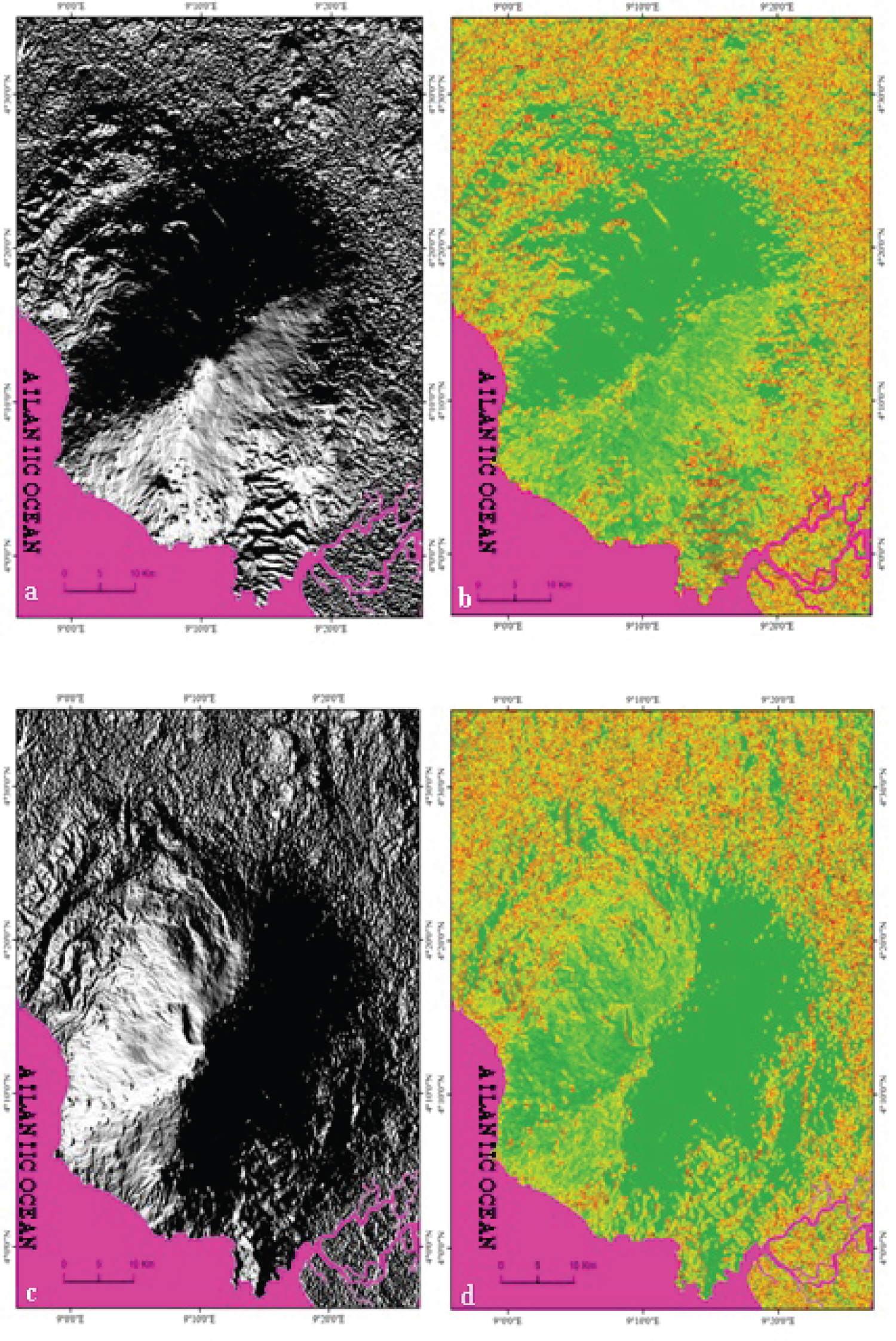
Figure 5: Maps of shaded relief....
Maps of shaded relief and the crest lines on the S and W flanks of Mount Cameroon. a) Shaded relief of the S flank; b) Crest lines of the S flank; c) Shaded relief of the W flank; d) Ridge lines of the W flank.
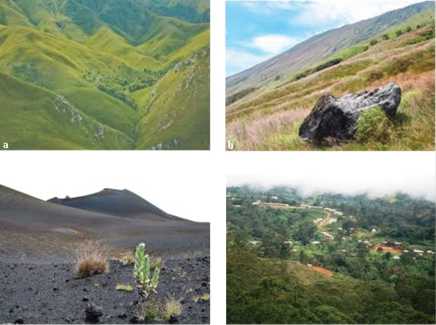
Figure 6: Section of slopes at....
Section of slopes at Mount Cameroon. a) Section of the W slope; b) Section of the NE slope; c) Another section of the NE slope; d) Section of the SE slope.
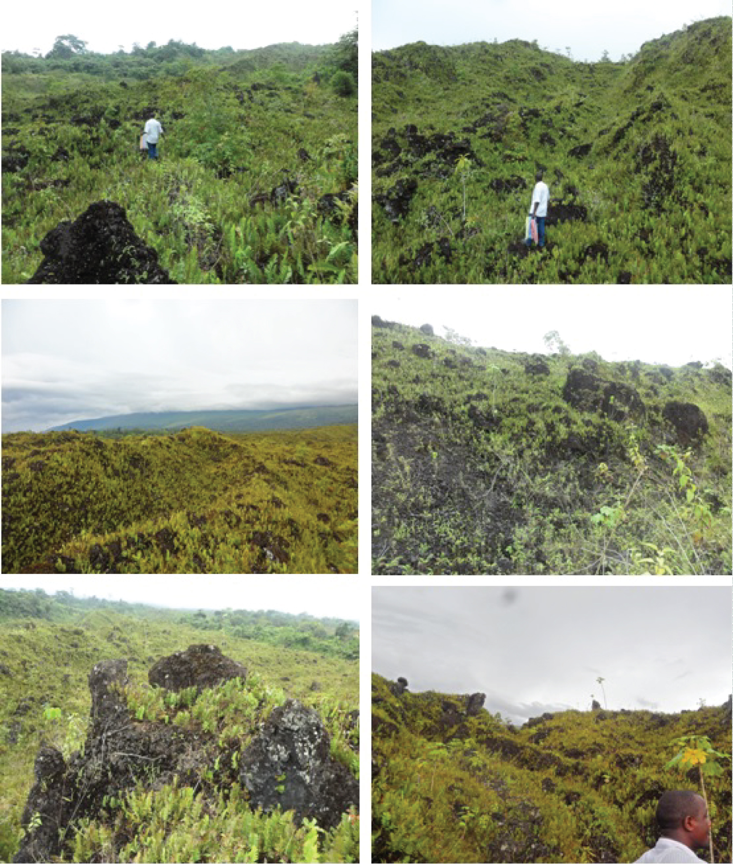
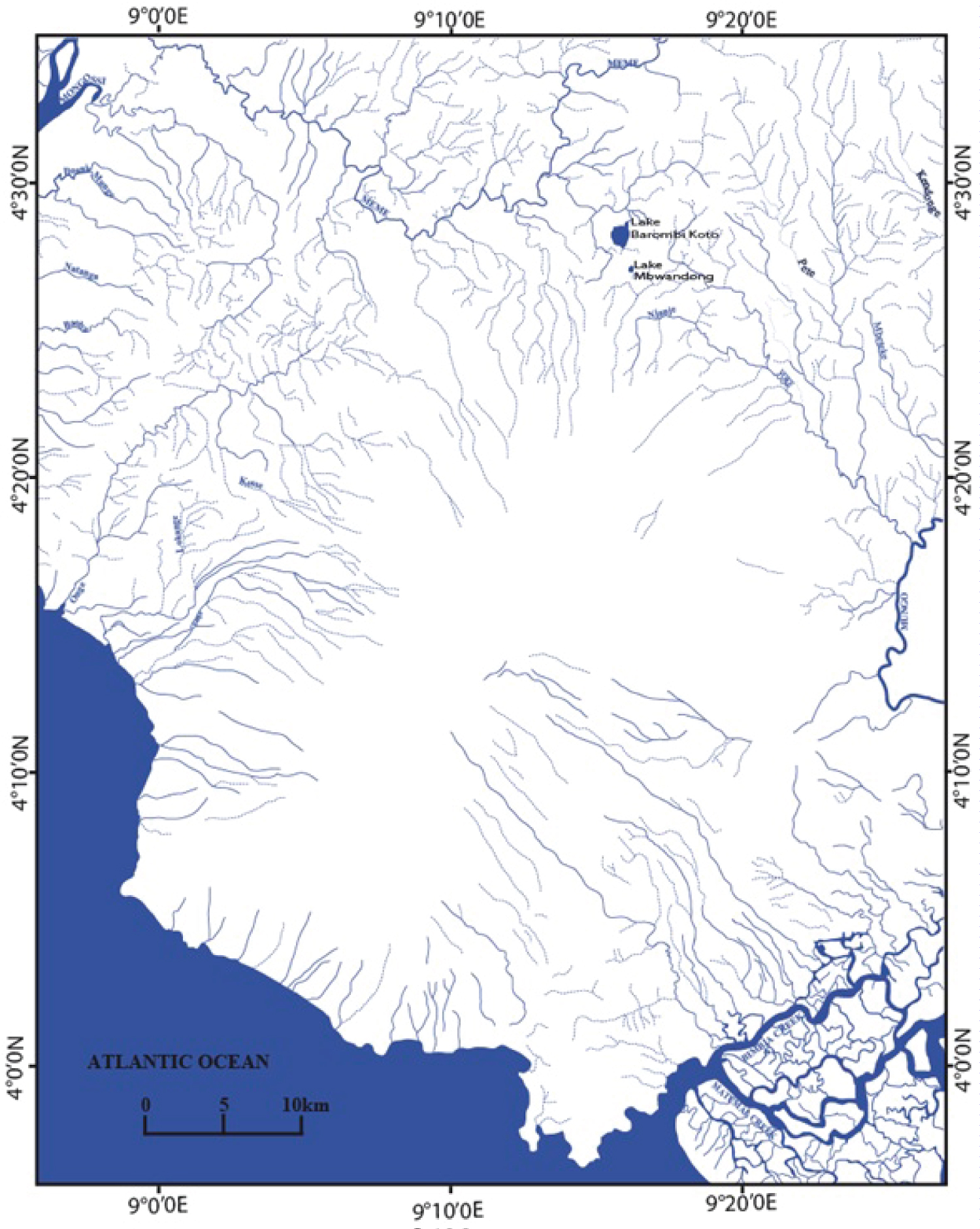
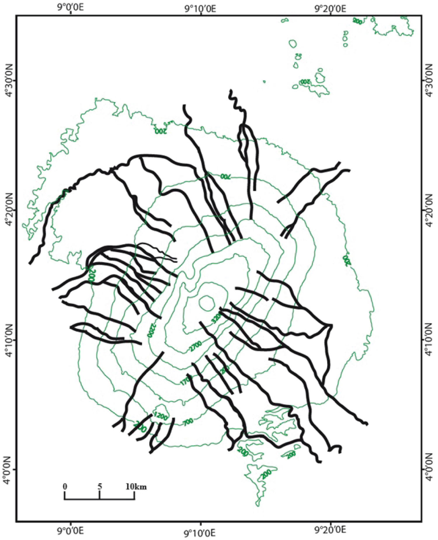
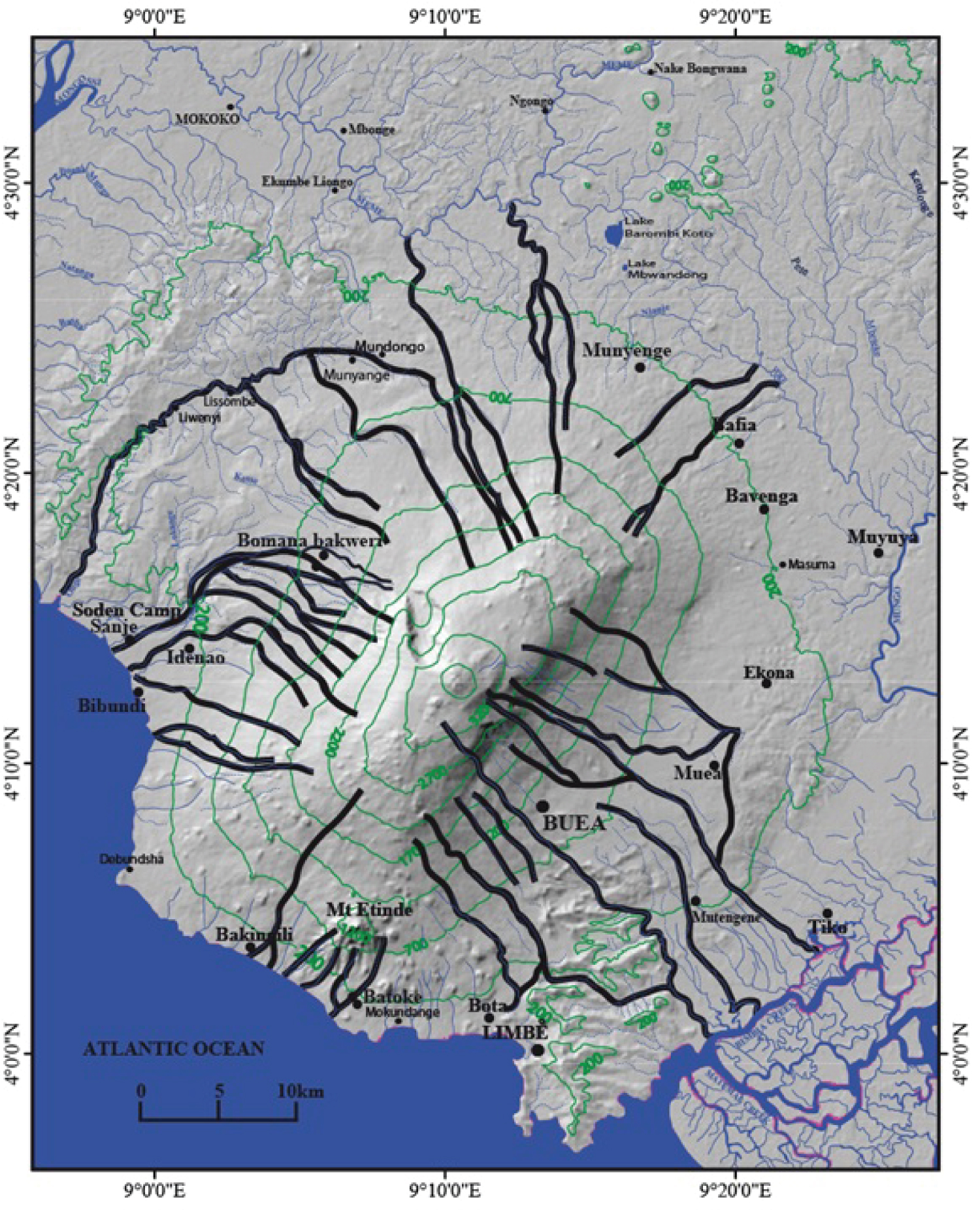
Figure 11: Map of probable flow...
Map of probable flow trajectories on a 3D topographic background.
References
- Déruelle B, Bardintzeff JM, Cheminée JL, Ngounouno I, Lissom J, et al. (2000) Éruptions simultanées de basalte alcalin et de hawaiite au Mont Cameroun (28 mars-17 avril 1999). Comptes Rendus de l'Académie des Sciences - Series IIA - Earth and Planetary Science 331: 525-531.
- Ngounouno I, Déruelle B, Montigny R, Demaiffe D (2006) Les camptonites du mont Cameroun, Cameroun. Afrique Comptes Rendus Geoscience 338: 537-544.
- Njome MS, Suh CE, Sparks RSJ, Ayonghe SN, Fitton JG (2008) The Mount Cameroon 1959 compound lava flow field: Morphology, petrography, geochemistry. Swiss J Geosci 101: 85-98.
- Ateba B, Dorbath C, Dorbath L, Ntepe N, Frogneux M, et al. (2009) Eruptive and earthquake activities related to the 2000 eruption of Mount Cameroon volcano (West Africa). J Volcanol Geotherm Res 179: 206-216.
- Tsafack FJP, Wandji P, Bardintzeff JM, Bellon H, Guillou H (2009) The Mount Cameroon stratovolcano (Cameroon Volcanic Line, Central Africa): Petrology, geochemistry, isotope and age data. Geochemistry Mineralogy and Petrology Sofia 47: 65-78.
- Wandji P, Tsafack JPF, Bardintzeff JM, Nkouathio DG, Kagou Dongmo A, et al. (2009) Xenoliths of dunites, wehrlites and clinopyroxenites in the basanites from Batoke volcanic cone (Mount Cameroon, Central Africa): Petrogenetic implications. Mineralogy and Petrology 96: 81-98.
- Suh CE, Stansfield SA, Sparks RSJ, Njome MS, Wantim MN, et al. (2011) Morphology and structure of the 1999 lava flows at Mount Cameroon Volcano (West Africa) and their bearing on the emplacement dynamics of volume-limited flows. Geol Mag 148: 22-34.
- Wantim MN, Suh CE, Ernst GC, Kervyn M, Jacobs P (2011) Characteristics of the 2000 fissure eruption and lava flow fields at Mount Cameroon volcano, West Africa: A combined field mapping and remote sensing approach. Geol J 46: 344-363.
- Wantim M, Kervyn M, Ernst GC, delMarmol M-A, Suh CE, et al. (2013) Morpho-structure of the 1982 lava flow field at Mount Cameroon volcano, West-Central Africa. Int J Geosci 4: 564-583.
- Wantim MN, Kervyn M, Ernst GGJ, Del Marmol M, Suh CE, et al. (2013) Numerical experiments on the dynamics of channelized lava flows at Mount Cameroon volcano with the FLOWGO thermo-rheological model. J Volcanol Geotherm Res 253: 35-53.
- Favalli M, Tarquini S, Papale P, Fornaciai A, Boschi E (2011) Lava flow hazard and risk at Mt. Cameroon volcano. Bull Volcanol 74: 423-439.
- Edwards RA, Whitmarsh RB, Scrutton RS (1997) Synthesis of the crustal structure of the transform continental margin off Ghana, northern Gulf of Guinea. Geo-Mar Lett 17: 12-20.
- Déruelle B (1982) Risques volcaniques au mont Cameroun. Rev Géogr Cameroun 3: 33-40.
- Suwa H, Yamakoshi T (1999) Sediment discharge by storm runoff at volcanic torrents affected by eruption. Zeitschrift fur Geomorphologie 114: 63-88.
- Kervyn M, van Wyk de Vries B, Walter TR, Njome MS, Suh CE, et al. (2014) Directional flank spreading at Mount Cameroon volcano: Evidence from analogue modeling. Journal of Geophysical Research: Solid Earth 119: 7542-7563.
- Del Marmol MA, Fontijn K, Atanga M, Njome S, Mafany G, et al. (2017) Investigating the management of geological hazards and risks in the Mt Cameroon area using focus group discussions. Advances in Volcanology 1: 373-394.
- Wembenyui EW, Collerson KD, Zhao J-X (2020) Evolution of Mount Cameroon volcanism: Geochemistry, mineral chemistry and radiogenic isotopes (Pb, Sr, Nd). Geoscience Frontiers 11: 2157-2168.
- Wan Y, Hu X, Zhong Y, Ma A, Wei L, et al. (2019) Tailings reservoir disaster and environmental monitoring using the UAV-ground hyperspectral joint observation and processing: A case of study in Xinjiang, the belt and road. IGARSS 2019 - 2019 IEEE International Geoscience and Remote Sensing Symposium, IEEE, Yokohama, Japan.
- Mulla DJ (2013) Twenty-five years of remote sensing in precision agriculture: Key advances and remaining knowledge gaps. Biosyst Eng 114: 358-371.
- Holness C, Matthews T, Satchell K, Swindell EC (2016) Remote sensing archeological sites through Unmanned Aerial Vehicle (UAV) imaging. 2016 IEEE International Geoscience and Remote Sensing Symposium (IGARSS), IEEE, Beijing, China.
- Gao T, Li K, Chen T, Liu M, Mei S, et al. (2020) A novel UAV sensing image defogging method. IEEE Journal of Selected Topics in Applied Earth Observations and Remote Sensing 13: 2610-2625.
- Fossi DH, Djomo HD, Takodjou WJD,Ganno S, Pour AB, et al. (2021) Structural lineament mapping in a sub-tropical region using Landsat-8/SRTM data: a case study of Deng-Deng area in Eastern Cameroon. Arabian journal of Geosciences 14: 2651.
- Zoheir BA, Gahlan HA, Al Faifi HJ, Kassem O, Al Bassam AM, et al. (2022) Field and remote sensing studies of the eastern Arabian Shield: implications for base and precious metals prospectively of the Ar Rayn terrane. Arabian Journal of Earth Sciences 15: 460.
- Déruelle B, N’ni J, Kambou R (1987) Mount Cameroon: An active volcano of the Cameroon Line. J Afr Earth Sci 6: 197-214.
- Suh CE, Sparks RSJ, Fitton JG, Ayonghe SN, Annen C, et al. (2003) The 1999 and 2000 eruptions of Mount Cameroon: eruption behaviour and petrochemistry of lava. Bull Volcanol 65: 267-281.
- Kampunzu AB, Popoff M (1991) Distribution of the main Phanerozoic African rifts and associated magmatism: Introductory notes. In: Kampunzu AB, Lubala RT, Magmatism in Extensional Structural Settings. The Phanerozoic African Plate, Springer-Verlag, Berlin, Germany, 2-10.
- Major JJ (2003) Post-eruption hydrology and sediment transport in volcanic river systems . Water Resource Impact 5: 10-15.
- Bohannon J (2007) Geophysics. Stalking a volcanic torrent. Science 316: 1562-1563.
- Smith GA, Fritz WJ (1989) Volcanic influences on terrestrial sedimentation. Geology 17: 375-376.
- Déruelle B, Ngounouno I, Demaiffe D (2007) The "Cameroon hot line”: A unique example of active alkaline intraplate structure in both oceanic and continental lithosphere. C R Geosci 339: 589-600.
- Déruelle B, Moreau C, Nkoumbou C, Kambou R, Lissom J, et al. (1991) The Cameroon line: A review. In: Kampunzu AB, Lubala RT, Magmatism in extensional structural settings. The Phanerozoic African Plate, Springer-Verlag, 274-327.
- Montigny R, Ngounouno I, Déruelle B (2004) Âges K-Ar des roches magmatiques du fossé de Garoua (Cameroun) : Leur place dans le cadre de la « Ligne du Cameroun ». C R Geosci 336: 1463-1471.
- Ngounouno I, Déruelle B, Guiraud R, Vicat J-P (2001) Magmatismes tholéiitique et alcalin des demi-grabens crétacés de Mayo Oulo-Léré et de Babouri-Figuil (Nord du Cameroun-Sud du Tchad) en domaine d’extension continentale. CR Acad Sci Paris 333: 201-207.
- Fail J-P, Montadert L, Delteil J-R, Valéry P, Patriat P, et al. (1970) Prolongation des zones de fractures de l’océan Atlantique dans le golfe de Guinée. Earth Planet Sci Lett 7: 413-419.
- N’ni J, Bonin B, Brousse R (1986) Migration de l’activité´ magmatique de la ligne du Cameroun : Réactivation de segments de failles anciennes du socle panafricain. CR Acad Sci Paris 302: 453-456.
- Moreau C, Regnoult J-M, Déruelle B, Robineau B (1987) A new tectonic model for the Cameroon Line, Central Africa. Tectonophysics 141: 317-334.
- Meyers JB, Rosendahl BR, Harrison CGA, Ding Z-D (1998) Deep-imaging seismic and gravity results from the offshore Cameroon Volcanic Line, and speculation of African hotlines. Tectonophysics 284: 31-63.
- Njonfang E, Ngako V, Kwekam M, Affaton P (2006) Les orthogneiss calco-alcalins de Foumban-Bankim: Témoins d’une zone interne de marge active panafricaine en cisaillement. C R Geoscience 338: 606-616.
- Ngwa NC, Lenhardt N, Le Roux P, Mbassa JB (2019) The Mount Cameroon southwest flank eruptions: Geochemical constraints on the subsurface magma plumbing system. Journal of Volcanology and Geothermal Research 384: 179-188.
- Perret FA (1937) The eruption of Mount Pelée 1929-1932 . Carnegie Institution of Washington, US, 125.
- Hovey EO (1904) The Grande Soufrière of Guadeloupe. Bulletin of the American Geographical Society 36: 513-530.
- Lacroix A (1904) La Montagne Pelée et ses éruptions. MASSON & Cie, Paris, 662.
- Tchop JL, Metang V, Dili-Rake J, Nana GV, Nguet PW, et al. (2021) The lahars of the south-east slope of mount Cameroon: Geological study, economic interest and impacts of their exploitation on the environment. Turkish Journal of Geosciences 2: 1-12.
- Yokoyama T, Aka FT, Kusakabe M, Nakamura E (2007) Plume-lithosphere interaction beneath Mt. Cameroon volcano, West Africa: Constraints from 238 U- 230 Th- 226 Ra and Sr-Nd-Pb isotope systematics. Geochimica et Cosmochimica Acta 71: 1835-1854.
- Okunishi K, Suwa H, Hamana S (1988) Hydrological controls of erosion and sediment transport in volcanic torrents. Hydrological Sciences Journal 33: 575-587.
- Suwa H (1995) Sediment transport by volcanic torrents of different scale. In: Osterkamp WR, Effects of scale on interpretation and management of sediment and water quality. Iahs Publication 226: 91-97.
- Legono D (2006) Sediment bypass modeling of volcanic rivers (A case study: Boyong River, Merapi Mount, Indonesia). Media Komunikasi Teknik Sipil 14: 142-149.
- Lalubie G (2013) Les Lahars et les laves torrentielles historiques aux Antilles françaises : Un risque hydro-volcano-géomorphologique majeur. Physio-Géo 7: 83-109.
- Lalubie G (2013) Volcanic hydro-geomorphology and the rediscovery of an ancestral (Carib, Kalinago) problematic in the Lesser Antilles: The case of the Montagne Pelée. Bulletin de la Société Géologique de France 184: 129-136.
- Chrétien S, Brousse R (2002) La Montagne Pelée se réveille. Comment se prépare une éruption cataclysmique . BOUBÉE, Paris, 243.
Author Details
Victor Metang1*, Legrand Joseph Tchop1,2, Rose Noël Ngo Belnoun1, Henri Appolinaire Kenzo1, Diane Marilyn Nkamga Mbakam1, Léa Grace Tene Kengne1, Pauline Wokwenmendam Nguet2 and Lucas Mouafo1
1Department of Earth Sciences, Faculty of Science, University of Yaoundé, Yaoundé, Cameroon
2Institute for Geological and Mining Research, Buea, Cameroon
Corresponding author
Victor Metang, Department of Earth Sciences, Faculty of Science, University of Yaoundé, I, P.O. Box. 812 Yaoundé, Cameroon.
Accepted: May 05, 2022 | Published Online: May 07, 2022
Citation: Metang V, Tchop LJ, Belnoun RNN, Kenzo HA, Mbakam DMN, et al. (2022) Application of Remote Sensing for the Mapping of Geomorphological Accidents of Mount Cameroon: Vectorization of the Probable Lava Flows Trajectories. Int J Earth Sci Geophys 8:059.
Copyright: © 2022 Metang V, et al. This This is an open-access article distributed under the terms of the Creative Commons Attribution License, which permits unrestricted use, distribution, and reproduction in any medium, provided the original author and source are credited.
Abstract
Natural hazards are common destructive phenomena that are preventable. Mount Cameroon, an active volcano on the Cameroon Volcanic Line, has emitted innumerable lava flows since the 19th century. The flows that moved in several directions were mapped mainly by field methods. In this article, the main basic data are the SRTM map on Mount Cameroon downloaded and imported to Arcgis 10.2 for processing. Four shaded reliefs and crest lines were generated on the slopes at N000° azimuths, N090°, N180° and N270° respectively with an inclination of the sun at 45°. The generated images helped to vectorize interconnected lines of depression, drained or not and which can serve as flow under the gravity of lavas or possible lahars to towns and villages located on the slopes or at the foothill. The innovation in this work is the combination of satellite imagery with field observations to vectorize the likely trajectories of lavic flows. Thus remote sensing appears as an efficient tool for modern cartography. It was then possible, through satellite image processing, to vectorize the geomorphological lineaments that could serve as the lava flows or lahars channels on all sides of the mountain. An efficient policy to manage disasters caused by volcanism at Mount Cameroon can now be envisaged.
Keywords
Remote sensing, Mount cameroon, Lavas, Prevention
Introduction
Natural hazards are destructive phenomena which have been systematically described by scientists in order to prevent harmful consequences. Since the 19th century, numerous volcanic eruptions took place at Mount Cameroon and were characterized by the lava flows moving in various directions. Several authors [1-13] studied Mount Cameroon eruptions, but no detailed synthesis on the probable direction of lava flows can account for major natural disasters. Apart from technological innovations, remote sensing can be used to monitor large areas through image processing: Disaster and environmental monitoring of tailing reservoirs along the Belt and Road [14], agricultural land monitoring [15], research of archaeological sites [16], correction of color distortion and lower brightness of defogging image [17], structural lineament mapping [18], metals research [19] and other works. SRTM (Shuttle Radar Topography Mission) images with a 90 m resolution were processed and used [20] to determine probable lava trajectories on Mount Cameroon. But these authors compiled hazard and risk maps by combining database of DOWNFLOW simulations with the input datasets, the estimation of lava flow lengths, and the distribution of inhabited areas and roads. Their methodology used is interesting but insufficient due to the absence of field data. In this work, we used an innovative approach combining field observations and remote sensing data.
Towns and villages (Buea, Tiko, Limbe, Ekona, Batoke, Bakingli, Idenau, Koto I, Bafia, Munyange, Bibundi) densely populated at the foot of the mountain, are probable areas subject to risk [7,10,21,22] during volcanic eruptions. It is therefore imperious to predict the direction of lava flows in future eruptions. The main objective of this paper is to vectorize from the processing of satellite images and maps, different geomorphological accidents recorded on the sides of Mount Cameroon in order to determine the potential directions of devastating lavas. Achieving this objective will not only find likely new lava trajectories compared to previous work, but also identify new risk areas.
Geological Setting
Mount Cameroon is an active volcano on the Cameroon hot line (Figure 1). The latter, orientated N030°E, extends from Pagalu island to Lake Chad, between the West African and Congo cratons [23]. In the oceanic domain, this hot line consists of six volcanoes, three of which are located on Bioko Island (Santa Isabel, Biao and San Carlos) and one each on Pagalu, São Tomé and Principe islands. The continental segment consists of seven volcanoes (Mt Etinde, Mt Cameroon, Mt Rumpi, Mt Manengouba, Mt Bambouto, Mt Mbam and Mt Oku) built on horsts alternating with grabens (Kumba, Tombel, Mbo, Ndop and Tikar) where predominate numerous monogenic cones and more than sixty anorogenic plutonic annular complexes [24]. All the anorogenic complexes have a typical alkaline character [25] and are aged between 6 and 70 Ma [26]. Trachytes and rhyolites are generally associated with plutonic complexes except the Kokoumi massif which is a unique example which includes significant volumes of lamprophyres [27]. Several continental transverse faults oriented N070E intersect the Cameroon hot line and extend into the fracture zone in the oceanic domain [3,24,25,28-32]. Several volcanic eruptions (1909, 1922, 1954, 1959, 1982, 1999 and 2000; Figure 2) are described on Mount Cameroon (4095 m above sea level) between 1909 and 2019 [1,4,8,33-35]. These eruptions took place in separate sites thus accounting for the various directions of lava flows [34,36]. None of all these eruptions destroyed human lives despite the location of towns and villages at the foot of the mountain. This article aims at seeking, from the processing of satellite images, probable directions of lineaments that can lead future lavas and predict disasters in the case that flows run towards anthropogenic works.
Methodology
The main basic data of this article is the SRTM (90 m resolution) map on Cameroon downloaded and imported to Arcgis 10.2 for processing. From the hillshade and "slope tools of 3D Analyst Tool contained in the Arc Toolbox window, 4 emerged shaded reliefs (hillshade tool) and the crest lines (slope tool) of Mount Cameroon were generated each time in azimuths N000°, N090°, N180° and N270° respectively with an inclination of the sun at 45°. Before using 3D Analyst tools however, the georeferenced image was previously processed with an extension of type "none" and the use of nuanced relief (Z) at 16 in "layer properties". To best vectorize the lineaments, all the processed images were imported to Adobe Illustrator CS4. As lavas can only flow mainly in depressions lines or between the ridge lines, all the interconnected depressions were digitized. A map of lineaments indicating the probable direction of lava flows was drawn on a topographic background generated from image analysis of the "Windows" window in Arcgis 10.2. Figure 3 shows a flow chart of the method.
The different images processed using the above-mentioned method are shown in Figures 4a, Figure4b, Figure 4c, Figure 4d, Figure 5a, Figure 5b, Figure 5c and Figure 5d. The images representing the shaded relief of Mount Cameroon highlight different lineaments at the azimuths N000°, N090°, N180° and N270° respectively. To better visualize the lineaments, the crest lines were generated at each azimuth. Between two consecutive ridge lines, there is naturally a depression line with more or less steep slopes. These depression lines created by the geometric arrangement of adjacent lava flows, the runoff from torrential rains and the gushing springs are drained by a river or not. Many interconnected depression lines can thus serve as a flow path for lava flows. It is also worth noting that a lava flow hardly crosses or cannot at all cross a ridge line. Mount Cameroon flanks (Figure 6a, Figure 6b, Figure 6c and Figure 6d) are characterized by a succession of hills separated by valleys with more or less straight or curved lines of depression. Several juxtaposed lava flows were observed on the flanks of Mount Cameroon (Figure 7). The processing of satellite images helps to best visualize these often drained valleys (Figure 8). Vectorized depression lines can lead lava flows to anthropic works. No interconnected lines and those limited by natural obstacles such as hills were not vectorized because they are less dangerous for the populations and human works. On a 2D topographic background, different geomorphological lineaments were vectorized along the interconnected and generally drained depression lines (Figure 9). A 3D topographic map (Figure 10) permits to better appreciate probable courses of lavas. Figures 7, Figure 8 and Figure 9 helped to draw the final map of probable lava flow courses (Figure 11). It is worth noting on Figure 11 that the localities of Bafia, Mundongo, Munyange, Lissombe, Liwenyi, Sanje, Bomanabakweri, Idenau, Bibundi, Bakingili, Batoke, Bota, Tiko, Mutengene, Buea, Muea and Ekona would be directly threatened by lava flows. However, the movement of lava flows depends on the parameters such as fluidity, viscosity, ejection power and velocity of lavas which is also directly a function of the slope of the vacuum line. A lava flux could use a line of depression and depending on the above-mentioned parameters, to reach the populations and human works. Some past eruptions [1,37] threatened certain localities (1959 and 2000 lava flows in Ekona and Buea respectively) but were harmless. However, the 1922 flows invaded the city of Idenau and the 1999 flows destroyed plantations, farms, roads and houses [7,21,22].
Discussions
Disasters caused by volcanic eruptions in the world are numerous; the prevention of various losses can be made by warning signs and the determination of the direction of lavas flow or lahar flows. The gases emitted during a volcanic eruption show no preferential direction; only the lava flows or lahars whatever their type can be vectorized if their ejection point is identified. This vectorization concerns not only volcanic rivers which drain flanks of active volcanoes [38-43], but also all the interconnected and or undrained depressions. The Grand Carbet de la Soufrière river in Guadeloupe, eight volcanic rivers around the Montagne Pelée mass if as well as five rivers (three major and two secondary volcanic rivers) in Martinique are typical examples of non-eruptive lahars among eruptive lahars [44]. At Mount Cameroon, observed lahars are eruptive; mud flows with debris of volcanic rocks of all sizes and are characterized by a rapid and gravitational flow [45]; the lahars generally affect the steep and poorly consolidated slopes. Between 1902 and 1929, the syn-eruptive lahars for diluting hot eruptive materials regularly used the partially buried hydrographic network on the slopes of Mount Pelée [46-49]. Thus, the 1922, 1959, 1982 and 2000 lavas which flowed towards the localities of Bibundi, Ekona, Bakingili and Buea respectively [22,25,34] using depression lines from the summit of the Mount Cameroon, could have caused huge natural disasters below. On the other hand, the city of Saint-Pierre and its inhabitants were wiped out in 1902 by heavy thunderstorm precipitation generating destructive flows in the main rivers of the volcano [48,50]. Recent Mount Cameroon lavas were more localized above 2000 m height [2] except those on the NE and SW flanks [20,37] which destroyed farms and could have killed people at Ekona and Bibundi. However, if the direction of the lava flows was mark out before the eruption, some mature crops could have been harvested, thus limiting losses. But uninformed of the direction of lava flow, the populations moved away messily from their dwellings.
The remote sensing, a tool by excellence for modern cartography, nowadays allows, through the processing of satellite images, to vectorize geomorphological lineaments that can be used to move lavas or lahars and thereby consider an efficient policy for disaster management due to volcanic eruptions. Mount Cameroon, the object of this work, is a clear example.
Conclusion
Numerous authors have highlighted recent or old lava flows at Mount Cameroon. The cartography of flows made it possible to visualize their direction as well as the levels of their stabilization on the sides of the mountain. The processing of SRTM images and the hydrographic network made it possible to highlight the interconnected depressions on all sides of Mount Cameroon. These depression lines created by the geometric arrangement of adjacent lava flows, the runoff from torrential rains and the gushing springs are drained by a river or not. The careful observation of the lava ejection area from previous work made it possible to trace via the hydrographic network and the interconnected depression lines undrained courses of flows in case of volcanic eruptions or non-eruptive lahars flow (not yet reported at Mount Cameroon). According to these lineaments, the localities (and their surroundings) such as Buea, Tiko, Limbe, Ekona, Batoke, Bakingli, Idenau, Koto I, Bafia, Munyenge and Bibundi were detected as risk areas by previous work and this work. The new risk areas identified exclusively by SRTM image processing are Mundongo, Lissombe, Liwenyi, Bomana Bakweri, Sanje, Bota, Mutengene and Muea. Remote sensing mapping via SRTM images therefore helps to generate geomorphological lineaments that can guide lava flows or lahars and thereby considered as an efficient policy to manage volcanic eruptions related disasters or non-eruptive lahars flows on slopes of Mount Cameroon.